East Farleigh, Kent
Gallants
Manor and Court
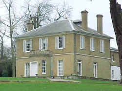
"The manor house at Gallants has an ancient
appearance, both within and without. The doors and windows
are arched and cased with stone. Much of the walls are built
with flint. After the death of Walter
Culpeper4a at Tonbridge in 1 Edward III (circa 1327),
the manor of Gallants
passed to his sons, Thomas, Geoffrey and John, and
afterwards to the Roper family." (Hasted's Kent, Vol. IV,
pp. 377-378).
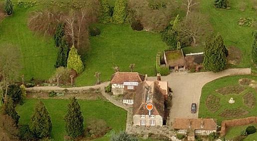
Gallants Manor
Photograph from Multimap.com (search ME150LF)
provided to Culpepper Connections in Nov 2010
by Duncan Spencer, chairman of the East Farleigh History
Society.
 Gallants
Court (right) is on the other side of the road and about two
hundred yards down the hill from Gallants Manor (above). Gallants
Court (right) is on the other side of the road and about two
hundred yards down the hill from Gallants Manor (above).
Gallants Manor/Court Location: 0.5 miles W
of East Farleigh, just S of the B2010.
National Grid Coordinates: TQ 727 532 Photograph
taken by Warren Culpepper, March 2000. |
Culpepers "of
East Farleigh"
 |
Walter Culpeper4p
of East Farleigh and Preston Hall, 1275-1321. Son of Sir
Thomas Culpeper3bh of Bay Hall. Walter, as the
Castellan of Leeds Castle, refused entrance to Queen
Isabella in 1321, and for which he was executed by Edward
II. |
| Thomas Culpeper5a
of Gallants in East Farleigh, 1307-aft.1351. He married Joanne and was
the son of Walter4p. |
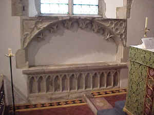
The tomb of Thomas Culpeper
of Gallants (1307-1351+)
St. Mary's Church in East Farleigh, Kent
The Culpepper coat of arms may be faintly seen in upper left
corner of arch
above the tomb. Photograph taken by Warren Culpepper, March
2000.
|
John Culpeper6a of
East Farleigh, c.1332-aft.1382. John, the son of Thomas, was
a member of Parliament for Kent in 1382. |
|
Richard and Ralph Culpeper9a
of East Farleigh, sons of Peter Culpeper and 1st cousins
twice removed of John Culpeper6a of East
Farleigh. |
|
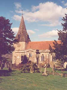 St. Mary's Church St. Mary's Church
On the north side of the rector's chancel in St.
Mary's Church is an ancient arched tomb with the Culpeper arms (drawing above)
thought to be that of
"Sir Thomas Culpeper5a of Gallants", who was reputed
to be the church's founder. His arms, quartered with
those of his mother, Joanne Hardreshull (argent, a chevron
gules between nine martlets) also are found in the east
window of the south chancel, called Pimpe's chancel. (Hasted's
Kent, Vol. IV, pp. 380-381.). St.
Mary's Church, East Farleigh,
Location: On the B2010, in the middle of East Farleigh.
National Grid Coordinates: TQ 734 533
|
East
Farleigh
East Farleigh stands among the
orchards of the Medway Valley. The village itself is high above
the river but there is a fine medieval bridge crossing it below.
Dating from the late 15th century, the bridge spans the 100 yard
wide Medway in five graceful arches. Cromwell's New Model Army,
under Fairfax, crossed this bridge in 1648 to take Maidstone in
one of the most important engagements of the Civil War. The
battle left 300 Royalists dead and more than a thousand taken
prisoner. The bridge is now a national monument. (Source: Sean
Connolly, The Hidden Places of Kent, Travel Publishing
Ltd., 1998, p. 96)
1831 Topographical Dictionary:
FARLEIGH (EAST), a parish in the hundred of MAIDSTONE, lathe of AYLESFORD, county of KENT, 2˝ miles (S.W. by W.) from
Maidstone, containing 1143 inhabitants. The church has at the west end a tower
and spire. An ancient stone bridge of five arches crosses the
Medway at the entrance to the village. East
Farleigh Location:
10 miles N of Goudhurst and 2 miles SW of Maidstone on the
B2010.
National Grid Coordinates: TQ 734 533 |
Last Revised:
02 Jan 2015
|
|


