Frindsbury, Kent, England
Wainscot
The Manor of Wainscot, alias Parlabiens-yoke,
was anciently the estate of a family of the name of Parlabien
during the reign of King Edward
II (1307-1327). Soon afterwards, it came
into possession of Culpepers of Aylesford (either Walter
Culpeper4 or Sir Jeffrey Culpeper5) in
which family it
continued until Sir Thomas Culpeper15, at about the end of
the reign of Queen Elizabeth (1558-1603), sold it to Edward Randolph.
Source: Hasted, History of Kent, Volume III, pages
538-539.
Location:
National Grid Coordinates: TQ 746 712 |
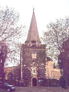 All
Saints Church, Frindsbury All
Saints Church, Frindsbury
Ancient Parish
Original registers
from 1669
The Culpeper involvement at this church, if any, is currently
unknown. More research is needed.
Location:
National Grid Coordinates: TQ
744 698 |
Frindsbury
1831 Topographical Dictionary
FRINDSBURY, a parish in the hundred of SHAMWELL, lathe of
AYLESFORD, county of KENT, 2 miles NW from
Rochester, containing 1562 inhabitants. The church, dedicated
to All Saints, stands on a commanding eminence rising from
the Medway, along the course of which river, and over the
town of Rochester, the view from the church-yard is
extremely fine. The parish is bounded on the south and east by
the Thames, and the Thames and Medway canal unites in it
with the Medway, on the banks of which are several wharfs.
Brick making is carried on to some extent, and chalk is found
in the parish. Upnor castle, erected by Queen Elizabeth to
defend the passage of the Medway, was for some time used as
a powder magazine: it is surrounded by a moat, and
consists of a central building, of an oblong form, connected
with a round tower at each end.
Location:
National Grid Coordinates: TQ
744 700 |
Last Revised:
02 Jan 2015
|
|


