Penshurst, Kent, England
Penshurst Park
John, duke of Northumberland, made a lease of the park of
Penshurst
to Sir George Harper and Thomas Culpeper10b, Esq., who granted their
interest in them to Christopher Roper. (Hasted Volume III, page
70).
Sir George Harper and Thomas Culpeper10b, were
half-brothers, the sons of Constantia Chamberlayn, who married
first, Sir Alexander Culpeper9b of Bedgebury and Hardreshull, and
second, Richard Harper. Note, also, that Sir Alexander was the
grandson of Walter Culpeper7b and Agnes Roper, and Agnes was the
daughter of Edmund Roper of St. Dunstan's Canterbury. Christopher
Roper, to whom the above lands were granted, was presumably a
member of this Roper family.
Location: On the east side of Penshurst Road, 1 mile
north of Penshurst.
National Grid Coordinates: TQ
527 447 |
St.
John the Baptist Church, Penshurst
Ancient Parish
Original registers
from 1558
The Culpepers removed from the Penshurst
area prior to the date of the oldest extant parish
registers. No monumental inscriptions have been found and
there is no tangible evidence connecting them to this
church.
Location: At center of Penshurst
National Grid Coordinates: TQ
527 438 |
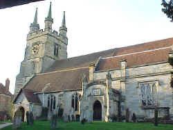
Penshurst Church, March 2000
Photo by Warren Culpepper |
Penshurst, Kent
One of the prettiest villages in Kent is Penshurst, which makes the most of its hilly wooded setting and its Tudor architecture. The houses at its core are all old - dating from two to four centuries ago and each with its own sense of charm and identity.
The heart of the village is the church of Saint John the Baptist, originally built in the 12th century and still containing elements from the 13th, 14th and 15th centuries. Of particular interest is the 15th century ornamental font. Almost as interesting as the church itself is the way it is reached - through an ancient lych-gate. The
two-story Tudor house which was built around the gate is now a test for geometry students, with its bulging walls and crooked beams hard-pressed to produce a right angle among them. Together with its
neighboring houses it makes up Leicester Square, although it would be hard to find a more tranquil counterpart to its namesake in the heart of the West End of London. Source:
Sean Connolly, The Hidden Places of Kent, Travel Publishing
Co., 1998, pages 66-68.
1831 Topographical Dictionary
PENSHURST, a parish in the hundred of SOMERDEN, lathe of SUTTON at
HONE, county of KENT, 4� miles (W.S.W.) from Tunbridge, containing
1392 inhabitants. The church, dedicated to St. John the Baptist, has a
spire steeple and three chancels, and is rich in ancient monuments.
The river Eden here meanders in divided streams, and unites with the
Medway in its course to Tunbridge. Penshurst castle, adjoining the
village, is a noble pile erected in the reign of Henry VIII, on the
site of an ancient mansion, which, in the time of William the
Conqueror, belonged to the Penchester family; but, since that of
Edward IV, to the Sydneys, from whom Sir Philip Sydney was descended.
In the neighborhood are remains of a Roman fortification. Location:
At the intersection of the B2128 and B2176, 14 miles WNW of Goudhurst,
16 miles SW of Maidstone.
National Grid Coordinates: TQ
527 437 |
Penshurst
Place
One of England's finest historic houses,
Penshurst Place dominates the rural landscape of Penshurst and commands fine views over the Weald of Kent. The medieval house, renowned for its galleried Barons Hall, was built of local sandstone in 1341. Two centuries later it became the property of the Sidney family, who continued developing and adding to the estate. Today it stands as an impressive,
and remarkably well-preserved, example of a defended manor house. A fascinating collection of
armor, tapestries, paintings and furniture fills the state-rooms. Outside, there is the original
ten acre 16th century garden, the Toy Museum, a Venture Playground
and extensive walking trails. Penshurst Place can also claim England's
second oldest cricket pitch. Source:
Sean Connolly, The Hidden Places of Kent, Travel Publishing
Co., 1998, pages 66-68. No Culpepper connection
to Penshurst Place has been discovered, but certainly the ancient
Culpepers would have been guests in this home, and it is a site well
worth visiting.
Penshurst Place Location: Just north of Penshurst on the B2176.
National Grid Coordinates: TQ
527 440 |
Last Revised:
02 Jan 2015 |
|


