Tonbridge, Kent, England
Tonbridge Rectory and Appurtances
Description: "The rectory of Tonbridge, with its
appurtances, and all messuages, lands, tenements, tithes, etc. in
the parish of Tonbridge, in the wards of Tonbridge, Southborough
and Brombridge, and in the great park of South-frith, and in the
park and lands enclosed, called North-frith, the Postern, and the
Cage, parcel of the rectory." In about 1555, Lady Elizabeth
Fane, widow of Sir Ralph Fane, sold the rectory to Henry
Stubberfield, yeoman, of Tonbridge, who sold it to Sir Alexander Culpeper11b
of Bedgebury.. Alexander sold it in about 1565 to William Denton,
Esq.
Location: Presumably next to the church. More research is needed. |
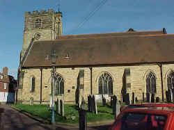 St
Peter & St Paul Church St
Peter & St Paul Church
Ancient Parish
Original registers from 1553.
No connection to the Culpepers has been
established.
Location: At
the intersection of the B2260 and B2021, near the Medway River.
National Grid Coordinates:
TQ
592 467 |
Tonbridge, Kent
Location: 10 miles NW of Goudhurst, and 12 miles
SW of Maidstone.
National Grid Coordinates: TQ
592 467
Tonbridge stands on the highest navigable point on
the Medway and as such has been able to exploit this position over
the centuries. There was an Anglo-Saxon settlement here and
perhaps an earlier Roman community. Its most important historical
landmark, on a rise in the center of town, is the ruined Norman
castle, of which there are substantial remains. The walls date
from the 12th century while the shell of the keep, as well as the
massive gatehouse and drum-towers, were built in the early 14th
century. Inside the wall is a mound which is thought to have been
the site of an Anglo-Saxon fort. The parish church of Saints Peter
and Paul shows mainly evidence of the style of architecture known
as early English, in this case being built in the early 13th
century. Subsequent restoration efforts and enlargements have
altered the interior of the church, but it retains a sense of
height and airiness that recalls the Middle Ages.
Source: Sean Connolly, Ed.,
"Tonbridge", The Hidden
Places of Kent, Travel Publishing, Ltd., 1998., pages 79-80. |
1831 Topographical
Dictionary
TONBRIDGE, or TUNBRIDGE, a market town and parish in the lowey of
TONBRIDGE, lathe of AYLESFORD, county of KENT, 14 miles WSW from
Maidstone, and 30 SE from London, containing, with part of the
chapelry of Tonbridge-Wells, 7406 inhabitants. This place is
supposed to have been originally called “Town of Bridges,”
from the stone bridges crossing the five streams into which the
river Medway here branches, of which the present name is a
contraction. A castle (by some supposed to have been built before
the Conquest, but generally believed to have been erected shortly
after, early in the eleventh century, by Richard, Earl of Clare, a
relation of the Conqueror), which was on a very large scale, and a
frequent scene of warfare, stood near the town, to which it
probably gave origin: it was besieged by William Rufus, soon after
his accession to the throne, the proprietor having declared in
favour of Robert, Duke of Normandy: it was afterwards taken by
King John, in his war with the barons; and subsequently was
besieged by Prince Edward, son of Henry III., on which occasion
the town was burned by the garrison, to prevent its giving shelter
to the assailants. Having ascended the throne, Edward was
sumptuously entertained here by Gilbert, Earl of Clare; and during
his absence in Flanders, his son, afterwards Edward II, when
administering the government of the kingdom, resided in this
castle, and, having been crowned king, took possession of it, in
consequence of the rebellion of its owner, after which it became,
with three others, the depository of the records of the kingdom.
The lordship, some time after, was the property of the family of
Stafford; and, on the attainder of the Duke of Buckingham (the
last powerful member of that family), in the reign of Henry VIII,
it was seized by the crown, with his other possessions, and the
castle suffered to fall into decay. The town consists principally
of one long and spacious street, containing some good houses, and
its situation, on the declivity of a hill, contributes greatly to
its cleanliness: it is partially lighted and paved: the only
public buildings are the town hall and market-house. A stone
causeway, at its entrance from London, was constructed, in 1528,
by John Wilford; and the principal bridge was erected, in 1775, at
an expense of £1100. The chief articles manufactured are
Tonbridge ware and gunpowder, but both to a less extent than
formerly. The river Medway was made navigable to this town about
the middle of the last century, and a considerable quantity of
coal and timber is brought by it from Maidstone. Two
representatives were sent to parliament from this town in the 23rd
of Edward I, but it has not since exercised the elective
franchise. |
Last Revised:
02 Jan 2015 |
|


