The Culpeper Basin
In the northern Piedmont Region of Virginia
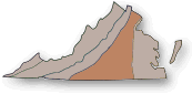
The Map above highlights the entire Piedmont Region.
Culpeper Basin extends from New Jersey down through the
Piedmont Region to an area in it south of Culpeper, VA.

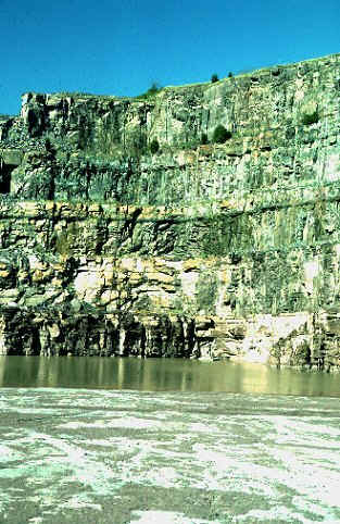
Triassic-age siltstone deposited in the Culpeper Basin
Photo from: William and Mary Department of Geology Web Site
The Culpeper Basin is part of the Piedmont Lowlands region that
extends from New Jersey to central Virginia. The Basin is one of the structural trough
depressions bordering the eastern front of the Appalachian Mountain system. The sediments
that formed the red bedrock material existing in the Basin were deposited during the late
Triassic to the early Jurassic Periods. These sedimentary rocks are predominantly
siltstones, but include shales, sandstones, and conglomerates... Residual alluvial
deposits of gravel, cobbles, and occasional boulders composed of quartzite, sandstone, and
weathered igneous rocks exist along stream terraces, including many rock types from
outside the Basin, transported downstream by the ancient Potomac River from outside the
Basin.
Source: Extracted from a report entitled, Phase I
Archaeological Survey at the Waverley Farms and Squire Tract, Prince William County,
Virginia, by Heidy P. Fogel, Ph.D. and John Bedell, M.A., May 1994,
Engineering-Science, Inc., Fairfax, Virginia.
Ancient Land
By William C. Burton
Special to the Washington Post
Wednesday, April 8, 1998; Page H04
© Copyright 1998, The Washington Post Company
The history of Earth is written in our region's rocks.
The Grenville Range
One billion years ago, parts of India, Antarctica, Australia and North and South
America had drifted together to form a supercontinent known as Rodinia. One part of that
process, the collision of North America with fragments of South America, pushed up a
mountain range that stretched from present-day eastern Canada through our region to
Mexico. Geologists have named it the Grenville Range, after an area in Quebec where the
eroded roots of this range are well exposed.
This event is called the Grenville orogeny. Orogeny is the geologist's term for the
mountain-building process.
On the surface today, we can find rocks that formed deep in Earth's crust in this
event. The core of the Grenville mountain range, these rocks were subjected to severe heat
and pressure when buried under the growing mountain and thus were deformed and
recrystallized by heat and pressure -- a process called metamorphosis.
The depth of burial is indicated by the particular combination of minerals in the
rocks, suggesting that the Grenville range was at least as high as the present-day Rocky
Mountains, which exceed 14,000 feet, two or three times as tall as today's Appalachians.
In the Washington area, Grenville rocks are mostly granite gneiss, a pale-colored rock
formed largely of quartz and feldspar with flattened aggregates of dark minerals, commonly
biotite mica or hornblende.
Granite gneiss underlies the broad valley between the Catoctin Mountain just west of
Leesburg and the Blue Ridge, the prominent ridge that forms the eastern boundary of the
Shenandoah Valley. Granite gneiss also underlies much of Shenandoah National Park,
including Old Rag Mountain.
Because these rocks had to have formed under the pressure of several vertical miles of
mountain and yet today are near the surface, we can conclude that erosion has removed all
of that overlying rock.
Geologists have dated Grenville gneiss as 1 to 1.1 billion years old by measuring the
amount of uranium in the rock that has decayed radioactively into lead. This technique is
similar to carbon-14 dating but involves a much slower rate of decay. It tells when
ancient rocks first crystallized from magma.
Another "rock clock," involving decay of an isotope of potassium into argon,
has been very useful in this region for determining when rocks recrystallized during
metamorphism. Dates of tectonic events in this article were obtained by these and similar
techniques and by determination of the age of fossils in sedimentary rocks.
The Iapetus Ocean
In plate tectonics, crustal plates that have come together often pull apart later at
about the same place. This is because older crustal breaks such as faults or subduction
zones are areas of weakness that can fracture as a plate begins moving in a new direction.
Tectonic processes that produced the mighty Grenville range shifted into reverse about
700 million years ago. After many millennia of crustal compression, uplift and erosion,
the crust in what is now the Washington area began to pull apart.
Stretching caused the crust to thin and crack, opening gaps through which hot magma
from the underlying mantle flowed upward. This lava-like material formed a granite
intrusion deep under the mountains about 700 million years ago.
Over the ensuing millions of years, the fractures reached the surface, allowing the
magma to erupt out of fissures as volcanoes about 600 million years ago. The rock left by
that event is basalt, which is dark and fine-grained and also underlies the world's
oceans.
During this time, not far from here, thinned and ruptured continental crust was being
pushed aside by eruptions of basaltic magma. The new rock was more dense than continental
crust, and, as it cooled, it sank deeper into the mantle to form the floor of a narrow but
widening ocean basin. Seawater filled the basin, creating a new ocean, named Iapetus for
one of Greek mythology's Titans.
The Iapetus Ocean opened approximately where the present-day Atlantic Ocean is. During
the opening, this area would have presented an alien landscape. Hot basalt lava poured out
of fissures, covering the eroded land surface with a sea of glowing, molten rock.
Wherever the lava found bodies of water, explosions of steam and clouds billowed. The
night sky may have been lit by spectacular fire fountains, like those seen during
eruptions of basalt on Hawaii and Iceland.
Despite the devastation, the impact on living creatures was minimal because sea
creatures had not evolved to live on land.
The huge lava flow of 600 million years ago is known as the Catoctin Formation, named
after the mountain ridge that extends north from Leesburg to Camp David in Maryland, where
the formation is well exposed.
The Catoctin Formation also underlies much of the Blue Ridge and Shenandoah National
Park, where it can be several thousand feet thick. Fissures that fed magma to the surface
during the basalt eruptions are known as dikes, in this region typically several feet
wide, filled with hardened basalt and appearing as stripes in the older Grenville granite
gneiss.
In Shenandoah National Park, spectacular exposures of dikes can be seen on Ridge Trail
on Old Rag Mountain, while north of the Potomac River in Maryland, they make up about half
of the total volume of bedrock.
After the eruption and cooling of the Catoctin lava flow, the landscape in our area
probably looked like that of eastern Washington state, where an eruption known as the
Columbia River Basalt poured out of fissures and covered an immense area a mere 15 million
years ago.
Structures preserved from the earlier flow can be seen in outcrops of Catoctin
Formation basalt in Shenandoah National Park. These include cavities formed by bubbles of
gas and distinctive columns that form during cooling and contraction of lava.
Though originally flat, the ancient lava today is exposed only along parallel ridges
because, during the later Appalachian orogeny, Catoctin Formation rock was folded upward
into a large arch.
The Blue Ridge and Catoctin mountains mark the limbs of the fold, where the formation
plunges below the land surface. The crest of the fold has disappeared, removed by erosion
that exposes the older Grenville crust and the feeder dikes underneath.
After the Catoctin eruption, the Iapetus Ocean continued to widen and deepen, and the
margin of the North American continent tipped downward. Rivers flowing east into the ocean
carried the eroded particles of the Grenville mountains and deposited them as sand and
silt atop the Catoctin lava flow. A resistant quartzite layer from this era remains,
overlying the Catoctin Formation along the Blue Ridge and Catoctin Mountain.
As the continental margin subsided farther and became the bottom of a shallow ocean,
various kinds of particles were deposited on the sand and silt. These were made of calcium
carbonate, from the shells and skeletons of countless marine organisms that died.
As these particles were compressed, they became limestone, which underlies the
Shenandoah and Frederick valleys. Tectonically, things stayed in this relatively quiescent
state for millions of years.
The Appalachians Rise
As the Iapetus Ocean opened, however, so would it close when the slow-moving currents
deep within Earth shifted again.
About 500 million years ago, a subduction zone formed under the western edge of the
Iapetus Ocean. This is a region, similar to those associated with the Aleutian and
Marianas trenches in the Pacific Ocean today, where the ocean floor slides under a
continental plate and plunges back into the planet's hot interior.
Ocean-floor crust descended into this subduction zone, causing North America to collide
with a structure that no longer is preserved but may have been an island chain of
volcanoes attached to the ocean floor crust, much like the Aleutians. Squeezing of the two
crustal blocks caused deformation and recrystallization of rock layers that had formed
during creation of the Iapetus Ocean.
First affected were fine-grained sedimentary rocks offshore. These were buried and
metamorphosed into a mica-rich rock called schist. As the landmasses pressed together and
the rock continued to deform, magma intruded into cracks, and slivers of ocean floor
basalt became incorporated, forming a complex assemblage of different igneous and
metamorphic rock types.
This assemblage underlies much of the Piedmont uplands west of the District. Nowhere
locally is rock of this age better exposed than at the Great Falls of the Potomac River,
where spectacular outcrops of schist have formed the bluffs and rapids, and at Rock Creek
Park, which has abundant exposures of igneous and metamorphic rock.
Formation of these rocks marked the beginning of the Appalachian orogeny, a
mountain-building process that took more than 200 million years and involved several
collisions with landmasses originally situated in the Iapetus Ocean. Untold numbers of
large earthquakes must have accompanied these collisions.
As land's surface rose in our region -- pushed upward by the squeezing of landmasses --
they shed sedimentary debris westward. On Massanutten Mountain, this debris is today
exposed as layers of sandstone and shale that overlie the limestones.
The climax came about 250 million to 300 million years ago when what is now the
continent of Africa, traveling northwest at several inches a year, collided with North
America to push up a mountain range along the east coast that stretched from present-day
Canada to Oklahoma.
In our region, the climax of the Appalachian orogeny caused folding and faulting of the
layered sedimentary and igneous rocks that had formed many millions of years earlier. It
produced the arching of the volcanic Catoctin Formation and overlying sedimentary rocks
mentioned previously and an accompanying downfold to the west.
Erosion subsequently would carve these folded and faulted rocks to produce what is
called the Blue Ridge physiographic province, the Shenandoah Valley and farther west, the
Valley and Ridge physiographic province. Mild metamorphism accompanied the deformation,
recrystallizing the originally black basalt of the Catoctin lava flow and dikes into a
rock commonly known as greenstone and changing fine-grained sedimentary rocks into yet
another mineral called phyllite.
The events that slammed Africa into North America 250 million years ago helped to weld
all of the continents into one giant landmass, the supercontinent known as Pangea,
bordered all around by one ocean. The Appalachians were a young mountain range in the
interior of this supercontinent and had a fairly dry climate typical of continental
interiors.
Southern Pangea, an assemblage of present-day Africa, South America, Antarctica,
Australia and India known as Gondwanaland, was experiencing an ice age. Four-legged
ancestors of dinosaurs and mammals were roaming, eventually evolving into their
better-known descendants during Pangea's 50 million years of existence.
The Atlantic Opens
About 200 million years ago, Pangea started to break apart. Once again, crustal
extension followed crustal compression, transforming our region from continental interior
into coastline and resulting eventually in the eastern margin of North America as we know
it today.
As with the opening of the Iapetus Ocean, the process was initiated by cracking,
stretching and thinning of continental crust.
Along the present eastern margin of North America, this resulted in a series of
fault-bounded valleys known as rift basins -- areas where continental crust failed to pull
apart enough to produce a full-fledged ocean basin. Instead, they slowly filled with
sediments, lava flows and igneous intrusions. The local rift basin, known as the
Culpeper
basin, extends from south of Culpeper, Va., to Frederick, Md.
The sedimentary rocks of the Culpeper basin are mostly fine-grained
siltstone that produces a deep red, clay-rich soil, familiar to anyone who drives past
construction sites in western Fairfax and Loudoun counties. Mostly deposited as a
shallow-water mud in lakes and slow streams, this rock recorded footprints of several
species of dinosaurs and other reptiles, best known from exposures in a large quarry near
Culpeper.
A coarser, reddish-brown sandstone from the east margin of the basin, near Seneca, Md.,
was quarried as building stone for the C&O Canal and the Smithsonian Institution's
Castle. A coarse conglomerate that forms outcrops along Route 15 north of Leesburg was
used for the distinctive columns in Statuary Hall of the Capitol Rotunda.
The igneous rocks included flows of basalt that erupted on the surface and subsurface
intrusions of basaltic magma known as diabase. Diabase is quarried extensively in Northern
Virginia to produce the familiar gray crushed stone found on roadways.
The Culpeper rift occurred in about the same area as rifting that
produced the Catoctin lavas 400 million years earlier, further evidence that plate
tectonics reuses older breaks in the crust. East of the District, in an area now under the
continental shelf, the rifting progressed to form a full-fledged break in the crust, and
the Atlantic Ocean was born.
As Africa parted from North America, the widening ocean basin -- again filled with
denser basalts from a mid-ocean ridge -- subsided and filled with sea water. The adjacent
continental crust also sank, allowing sea water to flood the eastern margin of North
America.
Sediments that gently dip east and underlie the present-day Coastal Plain were
deposited by encroaching seawater and by rivers carrying debris from the eroding
Appalachians.
The oldest of these deposits are more than 100 million years of age and preserved as
patches of sediment along the western margin of the Coastal Plain near the District. Like
the Culpeper basin deposits, they contain remains of dinosaurs, as
discussed in Horizon last July 9.
Younger deposits farther east, such as those exposed along Calvert Cliffs in Maryland,
contain shark's teeth and bones of marine animals much like modern ones, evidence of Earth
evolving into its present form.
Since formation of the Coastal Plain, erosion has been the predominant marker of the
geologic evolution of our region. Long after the end of the tectonic forces that produced
them, the Appalachians have continued to rise slowly but they are not getting taller. This
is because their upper layers are eroding away, making the mountains lighter and therefore
able to float higher on the underlying mantle. Thus, despite their great age and erosion
that has rounded their edges, the Appalachians have persisted in our area.
In recent years, geologically speaking, the Ice Ages resculptured contours of areas to
our north but never came far enough south to alter the landscape shaped by more violent
but far older processes.
And the Future?
Unlike some continental margins around the world, the east coast of North America is a
relatively quiet place tectonically. It does not have the frequent earthquakes of
California nor the volcanic eruptions of the Pacific Northwest and the Andes of South
America.
Yet all is not calm. Recent small earthquakes such as one that registered a 2.5
magnitude in Manassas last September remind us that crustal unrest continues.
The geologic record also contains evidence of relatively recent tectonic activity in
the form of faulted sedimentary layers in the Coastal Plain. Faults have been discovered
in excavations in the District and Virginia, and some of the affected deposits may be less
than 2 million years old, meaning that the faults are younger still.
The type of offset shown by these layers indicates crustal compression, not extension
of the kind that opened the Atlantic. Are the plates reversing gears once again? In 50 or
100 million years, might we, theoretically, come back to find belching volcanoes and
ground-wrenching earthquakes in formerly placid countryside? If so, the Washington region
would be a radically different place yet again.
William C. Burton is a geologist with the U.S. Geological Survey in Reston.
To Learn More
Read This Dynamic Earth: The Story of Plate Tectonics, by W. Jacqueline Kious
and Robert I. Tilling of the U.S. Geologic Survey (USGS). This publication, many local
geologic maps and other geoscience publications are available at the USGS Earth Science
Information Center in Reston (1-800-USA-MAPS)...
Last revised:
02 Jan 2015
|
