Hadlow, Kent, England
Oxen Hoath Manor (Oxen Hoath)
See separate page |
Fromans
Manor
Fromans, alias Goodwis, is a manor in Hadlow which
was formerly called, more properly, Fromonds, from a family of
that name, once possessors of it. Simon Fromond owned it as early
as 1258, It continued in the Fromond family until Richard Fromond
sold it to one in the family of Culpeper, in whose descendants it
continued until Sir Richard Culpeper9a of Oxen Hoath,
prior to his death in 1484, sold it back to the Fromond family.
(Hasted's Kent, Vol. 5, pp 183-184.)
Location: Unknown. |
Goldwell Manor
Goldwell Manor was sold by the Fromonds to the Culpeppers in
which family it continued until 1484 when Sir Richard Culpeper9a
of Oxen Hoath died with no sons. Goldwell then passed to Richard's
three daughters: (1) Margaret Culpeper, wife of William Cotton of Oxen Hoath; (2) Joyce Culpeper, wife of Edmund Lord Howard (one of
their daughters was Catherine Howard, fifth wife of Henry VIII);
and (3) Elizabeth Culpeper, wife of Henry Barham, Esq. In the
division of their inheritance, Goldwell was allotted to Margaret,
and afterwards passed to her grandson, Robert Cotton, Esq., of
Hadlow. (Hasted's Kent, Vol. 5, pp 185-186.)
Location: Unknown. |
Peckhams Manor
John de Peckham, in 1314, "held this manor of
the honor of Clare by knight's service," and in his
descendants it continued until it was sold to the Culpepers, in
whose name it was held until the death of Sir Richard Culpeper9a
of Oxen Hoath. Along with Goldwell, above, it subsequently passed
from the Culpepers to the Cottons. (Hasted's Kent, Vol. 5,
pp 187.)
Location: Unknown. |
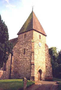 St.
Mary's Church, Hadlow St.
Mary's Church, Hadlow
Ancient Parish
Original registers from
1558. No evidence of Culpepper involvement in
this parish has been found, but the Culpepers were out of the area
before the date of the earliest extant parish registers. Location:
Off the SE side of the A26 in the middle of Hadlow.
National Grid Coordinates: TQ
634 497 |
Hadlow, Kent
Hadlow lies in the Medway Valley within easy
reach of Tonbridge. It is an attractive village with a wide main
street and a number of old houses in the center. These, however,
are dwarfed by the main feature of Hadlow, a curiosity known as
Hadlow Tower, or May's Folly. This 170 foot high tower is all
that remains of Hadlow Castle, which an eccentric industrialist
named Walter Barton May had built at the end of the 18th
century. The folly is aptly named on two counts. First it
represents the typical "Gothick" style of
architecture so dear in the romantic era, when defiantly
non-utilitarian follies were the rage. Second, it was reputedly
built so that May could have a view as far as the Channel, but
the intervening South Downs make this impossible.
Source: Sean Connolly, Ed.,
"Hadlow", The Hidden
Places of Kent, Travel Publishing, Ltd., 1998., pages 85.
Location: On the A26, 9 miles SW of
Maidstone, and 10 miles NW of Goudhurst
National Grid Coordinates: TQ
632 500
|
|
1831 Topographical Dictionary:
HADLOW, a parish in the lowey of TONBRIDGE, lathe of
AYLESFORD, county of KENT, 3½ miles (N.E.) from Tonbridge,
containing 1757 inhabitants. The church is a low structure dedicated to St.
Mary. This is an extensive parish, in which there are
several hop plantations and good pasture lands. It is
crossed by the river Sheet, which joins the navigable river
Medway a little above Brandt bridge. At Hurlake Bolt is a
flowing bolt by which, in dry seasons, the meadows can be
irrigated, this plan being found highly advantageous. |
|
Also See: West Peckham,
Wrotham, Dukes
Place,
Oxen Hoath and Old Soar
|
Last Revised:
02 Jan 2015 |
|


