Bletchenden, Kelsham, Summerhill, and Moatenden Manors
plus Kent's Chantry
Culpeper Sites at Headcorn, Kent, England
|
Bletchenden Manor
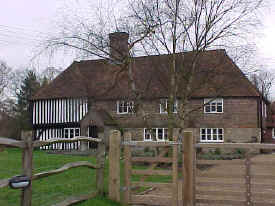 Bletchenden, alias Cruttenden, was part of the possessions of the Culpepers of
Aylesford. Peter Culpeper8a (the
great-great-grandson of Sir Thomas Culpeper3,
a direct ancestor of the modern-day Culpeppers) became the
owner in 1411, and it continued in the family down to Sir
Thomas Culpeper16a, 3rd Baronet, who died
childless in 1723. It then passed to his sister Alicia
Culpeper16a, who
had four husbands. The third was Thomas Culpeper, Esq., of
Hollingbourne, and the last was John Milner, M.D., of
Maidstone, to whom Bletchenden passed.
Bletchenden, alias Cruttenden, was part of the possessions of the Culpepers of
Aylesford. Peter Culpeper8a (the
great-great-grandson of Sir Thomas Culpeper3,
a direct ancestor of the modern-day Culpeppers) became the
owner in 1411, and it continued in the family down to Sir
Thomas Culpeper16a, 3rd Baronet, who died
childless in 1723. It then passed to his sister Alicia
Culpeper16a, who
had four husbands. The third was Thomas Culpeper, Esq., of
Hollingbourne, and the last was John Milner, M.D., of
Maidstone, to whom Bletchenden passed.
Source: Hasted, History of
Kent, Vol. V, pages 332-333
Photograph by Warren Culpepper, March
2000.
Location: 1
mile S of Headcorn, 0.3 mile west of the A274.
National Grid Coordinates:
TQ 838 431
|
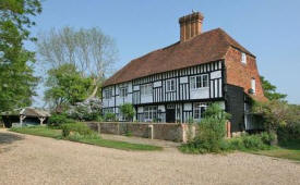
 Summerhill
Manor Summerhill
Manor
A mile west of the village and just north of the river (Beault)
lies Summerhill. This and Kelsham adjoining were originally one
estate and belonged to the Culpeper family (probably as part of
Moatenden). It is said that the
Bethersden marble used for the greater part of the church was
quarried on this estate. Source: The Parish, Church and
People of Headcorn, Kent. Page 6, Date unknown Photograph
by Warren Culpepper, March 2000.
Locations: 1 mile W of Headcorn on Moat /
Summerhill Road.
National Grid Coordinates:
TQ
823 447
|
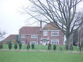
 Kelsham Manor Kelsham Manor
A mile west of the village and just north of the river (Beault)
lies Kelsham. This and Summerhill adjoining were originally one
estate and belonged to the Culpeper family (probably as part of
Moatenden). It is said that the
Bethersden marble used for the greater part of the church was
quarried on this estate.
Source: The Parish, Church and
People of Headcorn, Kent. Page 6, Date unknown
Photograph
retrieved 27 May 2011 from
Primelocation.com, a real estate website. Thanks to Carla Groen of
the Netherlands for pointing out this picture. The house was identified
as being on Four Oaks Road, has 8 bedrooms, 6 reception rooms and 6
baths. Asking price of Ł1,850,000.
Locations: 1 mile W of Summerhill on Summerhill / Four Oaks
Road,
then S at Dray Corner.
National Grid Coordinates:
TQ
814 444
|
Moatenden
Manor
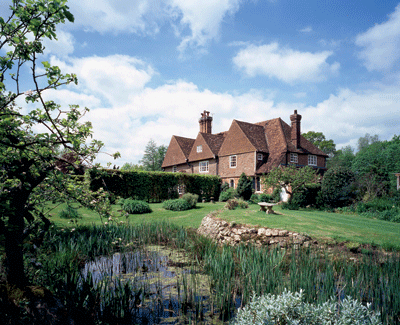 Moatenden (Mottenden) was originally a house of Trinitarian or Crutched
Friars founded in 1224. In 1548, Walter Hendley conveyed it to
his son-in-law Sir Thomas Culpeper10 of Bedgebury,
and he in 1550 passed it to his son-in-law, Christopher Sackville, Esq. Moatenden (Mottenden) was originally a house of Trinitarian or Crutched
Friars founded in 1224. In 1548, Walter Hendley conveyed it to
his son-in-law Sir Thomas Culpeper10 of Bedgebury,
and he in 1550 passed it to his son-in-law, Christopher Sackville, Esq. Source:
Hasted, History of Kent, Vol. V, pages 326-329.
Photograph
provided 9 Apr 2012 by Jenny Spence.
Location: 1.5 miles N of Headcorn, 0.1 miles W
of the A274.
National Grid Coordinates:
TQ 818 464
|
Kent's Chantry
Founded by John Kent in 1466. In 1538 the chantry was suppressed by
Henry VIII and in 1546 was given to Sir Anthony St. Leger to hold in
capite in knight's service. His son, Warham St. Leger, sold it
circa 1575 to Thomas Culpeper, who sold it in 1581 to Michael Beresford
of Westerham.
Source: Hasted, History of Kent,
Vol. V, pages 330-331.
Location: The Chantry no longer stands, but its site is in
the middle of Headcorn, at the junction of Grigg
Lane and Oak Lane.
National Grid Coordinates:
TQ
840 443
|
Historical
Notes on Headcorn
1450: Among the 80 men of Headcorn
to whom pardons were given in connection with the Jack Cade
Rebellion was "William Culpeper of Bedgebury". [Culpepper
Connections! comment: The Culpepers came into possession of Bedgebury
in 1425 when Walter Culpeper married Agnes Roper, the young and
childless widow of John Bedgebury. There are no known sons or
siblings of Walter named William, so it seems unlikely that this
Culpeper was "of Bedgebury". Perhaps the rebel was
William Culpeper8
of Aylesford, brother of the first Culpeper to have held Bletchenden
Manor, Peter Culpeper8.]
Circa 1450: "...when Headcorn had reached the height of its
prosperity, a further rebuilding (of the church) took place and
the work seems to have been chiefly that of the unknown Culpeper
whose arms are over the west doorway and upon the tomb in the
south wall just outside the Lady Chapel. On a silver field a red
engrailed bend with a crescent (on one of the shields) for cadency
(second son)... [Culpepper Connections!
comment: Most likely, the Culpeper in question was Peter
Culpeper8 of Bletchenden.]
1547: "In 1547 this Chantry (Headcorn) with all the
others was suppressed. The property of the Chaplain, the Ł10
for the poor and the upkeep of the Church, all were taken away
and given to the Ulcombe St. Legers who in due course parted
with it to the Culpepers and today only the name Chantry remains
to recall a pious benefaction impiously stolen in the name of
religious reform. N.B. The Chantry was at the junction of Grigg
Lane and Oak Lane."
1599: Lease on the parsonage and Lordship of Headcorn by
St. John's College, Cambridge to Thomas Culpeper12 of Wigsell in
Sussex in which the lessee agrees to pay the annual Ł5 to the
Vicar.
1604: "Our Chancel lacketh repairing both of the
roof and elsewhere, herein Mr. Culpeper (Thomas12 of Wigsell)
is faulty, who hath the lease of the parsonage, or Christopher
Fullage who occupieth it under him."
Source: The Parish, Church and
People of Headcorn, Kent
|
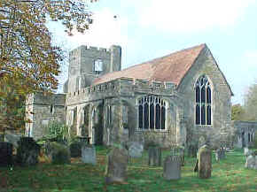
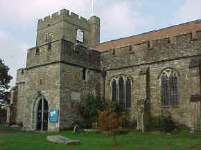
Parish Church of St.
Peter and St. Paul,
Headcorn, Kent
Location: on A274 in the middle of Headcorn
National Grid Coordinates:
TQ 833 442
|
|
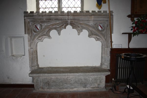 |
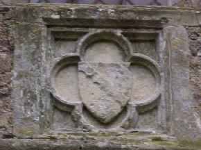
Culpepers at St. Peter and St.
Paul
The Culpeper arms are over the west doorway (pictured at left) and upon the tomb in the
south wall just outside the Lady Chapel (bottom left).
The tomb is set under a
double-feathered arch with floral ornaments now partially
mutilated. A rich carving of flowers is In the spandrels, and the
Culpeper arms are in quartrefoils. Presumably,
the otherwise unidentified Culpeper who erected the arms and lies
in the tomb is Peter Culpeper8 of Bletchenden.
All photographs except that of the tomb by Warren Culpepper, Oct 1999.
Tomb photo courtesy of
Dave Godden, provided March 2010
|
|
Village of Headcorn
Location: 9 miles NE
of Goudhurst, on the A274.
National Grid Coordinates:
TQ 833 442
1831 Topographical
Dictionary
Headcorn, a parish in the hundred of Eyehorne, lathe of
Aylesford, county of Kent, 8˝ miles SSE from Maidstone, containing 1191 inhabitants.
The church, which
is dedicated to St. Peter and St. Paul, is principally in the
later style of English architecture. Headcorn
is a decayed market town, situated on a branch of the river
Medway.
Last Revised:
02 Jan 2015
|
|


