Leigh, Kent, England
Ramhurst Manor
During the reign of Edward I (late 13th
century), Ramhurst
passed to the Culpepers, one of whom, Walter4a, paid
respective aid for it to King Edward III as the sixth part
of a knight's fee. It continued in the family for several
generations, and was eventually sold to the Lewknor family.
(This reference was apparently in Hasted's History
of Kent, but cannot now be found.)
Location: Just east of the A21, on
Powder Mill Lane.
National Grid Coordinates: TQ 563 468 |
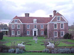
Ramhurst Manor, March 2000
Photo taken by Warren Culpepper
See: "Haunted House
Story" |
Great Barnetts (Bernet)
 Sir Thomas
Culpeper6 will of
1428: "The manor of Bernet in Leghe, Penserst,
Bitteberg and Tonbregge, with the mill of Greenerssh and lands called
Scottegrove in Asshe, Gatewicke mede in Otteford, and rents and farms
in Sele and Sevenoaks, to Thomas my son and his heirs, remainder to
Nicholas his brother, remainder to the heirs of me and Joyce lately my
wife, remainder to my right heirs." Sir Thomas
Culpeper6 will of
1428: "The manor of Bernet in Leghe, Penserst,
Bitteberg and Tonbregge, with the mill of Greenerssh and lands called
Scottegrove in Asshe, Gatewicke mede in Otteford, and rents and farms
in Sele and Sevenoaks, to Thomas my son and his heirs, remainder to
Nicholas his brother, remainder to the heirs of me and Joyce lately my
wife, remainder to my right heirs."
Leigh (on the northwest, and called Leghe in the will), Penshurst
(on the southwest, and called Pensert in the will), Bidborough (on the southeast,
and called Bitteberg in the will), and Tonbridge
(on the northeast, and called Tonbregge in the will), form a
parallelogram. Great Barnetts (called Bernet in the will) is in Leigh
today, but its lands once spilled into each of the other three
parishes.
Mr. James Gravell wrote on 23 Jul 2003: "Over the years, the spelling
has changed to barnetts (which originally meant 'burnt clearing' or so
I have been told), and the house beside the Moat seen on the
map, is
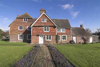
called Great Barnetts (aerial
photo). It is about the same age as Ramhurst Manor
(15th + 16th centuries). There's also a Barnetts Road in the village.
I know because I call it home. Great Barnetts house and farm was owned
by the nearby Penshurst Place estate until
the 1920s, but the former farmhouse and its land are both now owned
separately."
On 25 Mar 2011, Mr. Gravell followed up with the photograph above
and said: "The picture was taken in Spring 2007 a little while
before my mother sold the house. It was our family home for 40
years, but of course has had many owners and occupants since it was
built, and a new chapter has begun.
"The house was originally constructed circa 1580, it is thought,
with alterations since. The building has many ancient oak beams,
and the house is built adjacent to a moat which shows evidence of
occupation between 1270 and 1320. May be in later centuries the
need for defence was reduced, the moated site was restricted, or
damp perhaps, so they rebuilt a more modern house nearby. But if
you had some good beams available, you would make use of them,
surely? Only a carbon dating test on the house beams today would
reveal what century the oaks grew and that hasn't been done of
course. But to be big enough to be cut down and used as a beam, in
which year would the tree have to start growing? Eight or nine
hundred years ago may be? and still in use....
"Here are other links, which may be of interest:
Leigh Historical Society: Great Barnetts (history and photos)
British Listed Buildings: Great Barnetts Farmhouse, Leigh
|
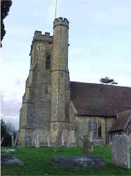 St
Mary's Church, Leigh St
Mary's Church, Leigh
Ancient Parish
Original registers
from 1592
The Culpepers left this area prior to the
date of the earliest extant parish registers. Their
involvement in this parish, if any,
is currently unknown. Further research is needed.
Location: On the main road, in the
middle of Leigh.
National Grid Coordinates: TQ
548 466
Photograph taken by Warren
Culpepper, March 2000 |
Leigh, Kent
1831 Topographical Dictionary
Leigh, a parish partly in the hundred of Somerden, but chiefly in that
of Codsheath, lathe of Sutton at Hone, county of Kent, 3ľ miles W
from Tunbridge, containing 876 inhabitants. The church, dedicated to
St. Mary, contains some ancient monuments, and considerable remains of
richly-stained glass: it had formerly a chantry, which was suppressed
by Edward VI. The river Medway bounds the parish on the south; and
there are mineral springs possessing properties similar to the water
of Tunbridge Wells. Location: On the B2027, 14
miles SW of Maidstone and 14 miles NW of Goudhurst
National Grid Coordinates: TQ
548 465 |
Last Revised:
02 Jan 2015
|
|


